
At first I did not get trail running. “Why would anybody want to run uphill?”
The downhill part was obvious and I was used to it, even with a heavy pack, but running uphill seemed energy inefficient to me. The seconds saved over a brisk walk did not seem to warrant the extra effort required. So I started jogging along the jeep tracks from Rhodes Memorial towards the city bowl, choosing the more level ones at first.
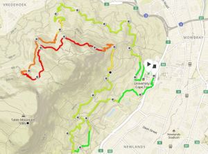
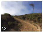
In contrast I have always enjoyed single tracks, flying along, having to pay attention in order to avoid a stubbed toe, crash or worse: a tumble. When Trevor Ball introduced the genius Two Ocean’s Trail Run route he connected some of the best single tracks in the area to make a truly fantastic and challenging route. For normal folks this would take 3h plus to complete and a large dose of effort so here I describe a shorter version – manageable in a quick 1h30 to 2h session. My Movescount gps file can be found here.
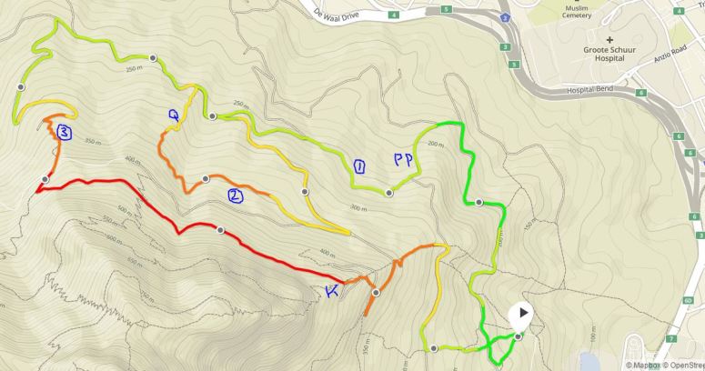
Start:
From Rhodes Memorial parking area take the single track path for 100m up to the first jeep track contour. There are several variations here that all lead to the same point. Turn right and follow the jeep track for a few hundred meters into a shaded area. The track turns downhill at a gentle gradient. At the first fork stay left as the track turns sharply left and uphill. Immediately stay left and head up Plumpudding Hill. 100% runnable if you are strong and trying to prove your manliness! 2/3 of the way up the jeep track turns sharp left. A lone tree is visible above.
The first of our three single tracks start in this corner on the right. The vague track dips into the gully and climbs up the other side to cross a rusted barbed wire fence to eventually join a jeep track. Enjoy the cruise along this. You will meet a T-junction in a s-curve of the main jeep track. The Woodstock shooting range is below you in the gum trees. Turn left and up the slight hill which levels out after a couple of hundred meters. Just before the dry stream crossing there is a jeep track going uphill to the King’s Blockhouse. (If you continue straight here you miss out the second single track but rejoin the route a few hundred meters ahead.)
Up this hill, once again 100% run-able. After a little distance the track levels out (maybe you get to pass some mountain bikers on this section). The branch to the right is our choice. This ultimately leads to Tafelberg Road and can be used as a short cut, but not today. Our second single track awaits on the right, where the ground turns grey. Easy running through fynbos at its best leads us into a cork tree forest. We slowly lose a bit of height to reach the ruin of the Queen’s Blockhouse.
From here it is a short but very steep descent to a jeep track. Turn left. [Turning right would take you back to the top of the hill above the shooting range.] Through a dip and out the other side. At the top of the hill turn sharp left onto a zig zagging jeep track which snakes up the ridge in large arcs. At a point where the track levels out in direction City Centre there is our third single track which starts with a few steps and is marked by a cairn. Up this to the signal cannons just below Tafelberg Road. Cross the tar road onto a single track leading uphill. 50m on there is a left fork. Take this and it will level out pretty quickly. This is the lower Contour Path. All the way along here to just behind the King’s Blockhouse.
When standing at the cannons below the Blockhouse it is easiest to take the gently descending jeep track to the left. This snakes downhill. Once you have completed a complete S-curve you will see a wooden bridge and mountain bike track heading down the crest of the ridge. Down this. Enjoy the baarp! You will be spat out on top of Plumpudding hill to your left (facing out). You can either head down this and back to the start or find the super steep single track directly down from the beacon to the jeep track that you started from earlier on. As you can see from the map there are many options for shortcuts and more (or less)direct lines to be explored.
The coffee and cake at the restaurant is much deserved, the view is not bad either!
