
 Deserves to be one of the great hiking trails in South Africa! Remote, authentic and adventurous. You are continuously confronted with little rock scramble detours which highlight a kloof, waterfall, rock arch or just spectacular view. There are many, many signs naming local plants throughout. This is a real treat and everybody will get a better sense of our local plant life.
There are shorter trail options available too and a couple of day hikes too.
Pretty but super busy in flower season (Aug and Sept)
Overview stats:
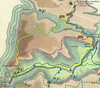
Distance: 52 km
Total Ascent: 1800 m
Total Descent: 1800 m
Style of route: circular
Normal Duration of hike: 4 to 5 days
Landowner: Oorlogskloof Nature Reserve. For permits and further info call (027) 218 1159
Events: Ugene Nell holds the Oorlogskloof Trail Run here in April and this is a fantastic way to experience the terrain for those that like to move fast but don’t necessarily see much of the surroundings.
Description:
We collect our permits in Nieuwoudtville at the Nature Conservation Office. Nicolette is helpful with maps etc. We check into the Wapad Guest House in Nieuwoudtville and sort kit for tomorrow’s early start. It is super basic but a roof over our heads (and a roaring fire) is all we need for the night.
Frost awaits as we drive to Groot Tuin (6 km back towards Vanrhynsdorp you see the turn off to the left, then it is another 10 km on the good dirt road).
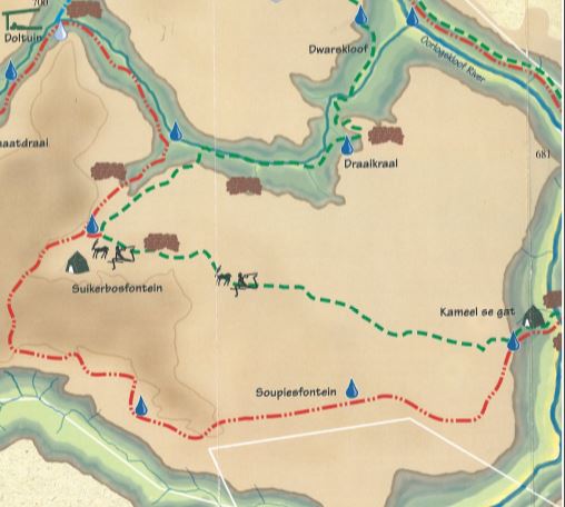
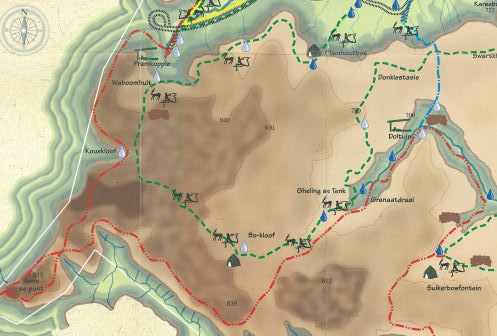
Day 1: 12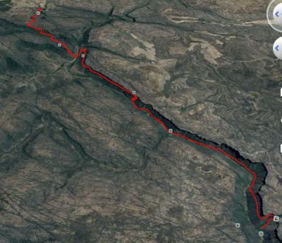 km Groot Tuin to Kameel se Gat
The last mobile reception is in Nieuwoudtville or close to the escarpment overlooking Vanrhynsdorp. We park our car under the pine trees as instructed and start our walk. There is a perennial stream 87m into the hike. Don’t rely on this in summer though. The 4km to Brakwater takes us 2 h at an easy pace. The hut looks amazing. We decided to do the first two days as one so this ended up in a pretty long and tough day. It was the hardest day of the 4. I would probably do it again in that way though.
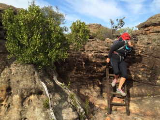
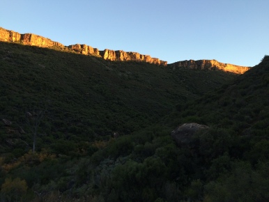
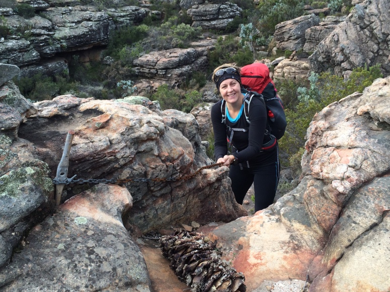
 A short while after the Brakwater hut we cross the stream while still on the jeep track. The two logs that symbolise a bridge are not confidence inspiring enough so we slide across like crabs anticipating a cold plunge. A short sharp hill and we turn off onto pleasant single track. Views are great and we see the Kareebos hut below us. The trail descends and then the tough boulder hoping section starts along the base of the river. You wind in and out of boulder fields which makes going slow and tough. Finally the climb up the slope to the Driefontein waterfall. We were told that unfortunately the hut’s roof had a leak (more like it did not have a roof) so we descended to Kameel se Gat back at stream level. Glad we did not have to do that on cold legs, first thing in the morning. Having said that the sun set views from the top must be amazing.
The night proved to be pretty cold and it took us a while to get going in the morning. Glad I had packed porridge for breakfast – quick and easy to make a warming meal on my MSR.
Day 2: 12km Kameel se Gat to Doltuin
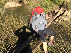
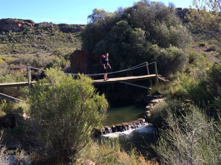
We cruise a few minutes down to the river and cross the smart bridge to the far bank. The ascent up the far bank take us 45 minutes or so. It finishes with an amazing chimney and rope/ladder combination which spits you out on the escarpment. Staying left we cruise on easier going that the previous day. As we descend down into the valley we pass some graves close to the path under a bunch of trees. I can’t imagine a better place to rest in peace. The path continues a few km to reach the Doltuin hut at what seems to be the head of the valley.
Here it is possible to take the escape route which cuts out the last day. We take a stroll around in the evening to loosen the legs. The river is full but the water is cold so we decline a swim in the river.
Enjoying the last few rays of light on the stoep we settle in for soup and an early dinner. Tomorrow is a long day.
Day 3: 15km Doltuin to Pramkoppies
The early section meanders up the valley. You can see the path from the hut as it ascends the head of the valley. We fill up water bottles under some trees which is a really pretty spot.
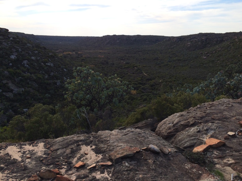
The climb up Granaatdraai is not too bad and we quickly find out selves on top. A cool wind is blowing so we walk in long sleeves all day. Today is the day of 10 rock arches and we start counting. We make good time and have lunch at the turn off to Arrie se Punt. We leave our bags here and scamper along the loop to quickly reach the outlook. You get mobile reception here and I respond to some birthday messages. Weird being drawn back into that seemingly foreign world. We take photos and admire the view of Gifberg, Vanrhynsdorp and the VanRhyns Pass (another Thomas Bains masterpiece). The walk back to the junctions takes us through some interesting kloofs and rock formations, well worth the extra little loop.
We continue our count of rock arches as you can see here.
A bit of open ground and then we start to descend along the side of Pramkoppie. The path shows signs of erosion and needs a bit of TLC but we manage it quickly in the afternoon sun. A short stroll along the valley floor to the most beautifully located hut below red cliffs and close to some trees and a stream. We soak up the rays. A great way to spend my birthday.
The water spot is among the bushes behind the hut and is marked so are the toilets at the huts. No roof, just au Naturel long drop.
The next day is our last so we plan to leave a little earlier to accommodate the drive home too.
Day 4: 9 km Pramkoppie to Groot Tuin
 A short distance from the hut we visit rock art in a cute shelter. The path ascends the valley slope and we hear baboons announcing themselves. Today the path skirts across the top of the fairly flat escarpment and we get great views. The grey skies add to the scene and bring out the colours of the land. When you are almost at the junction to Groot Tuin you are led into the heart of Spelonkop. Narrow Rock passages turn this way and that until you are spat out on the path you came in on. A short up hill and a stroll through the initial grove of Poplars lands you back at the car.
Recommended Tactics:
The Rock Pigeon Route is comfortably completed in either 4 or 5 days. Day 2 (on the 5 days schedule) is the toughest going as you have a long section of navigating through a boulder field which takes its toll. This was the second section of our Day 1.
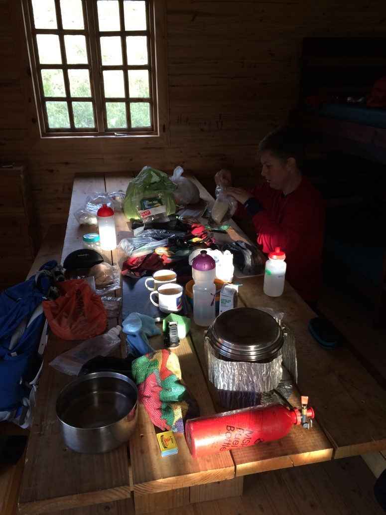
Huts offer bunk beds and wooden tables and benches to house between 12 to 16 pax. Huts all have solar electricity for lighting and you can charge your electronics. A three prong socket is available. Bring your adapters.
I recommend that you drive to Nieuwoudtville on day one and get sorted in accommodation there and then start the hike. This leaves enough time to combine day 1 and 2 of the hike. The quoted times are conservative but not overly so. Going is generally slower than on other trails due to the path weaving in and out of boulders, gullies and interesting features.
There is no reliable mobile phone reception along the trail except at Arrie se Punt and the edge of the escarpment at Pramkoppie.
Water could be a problem in summer and it gets pretty cold in the middle of winter so in between season are probably best for hiking.
Nutrition / Hydration availability:
It is quite a good idea to carry a few extra water containers to fill up at the overnight huts. Generally the water source is about 50 m to 100 m away from the hut.
Other info:
Closest Food Retailer: Clanwilliam has a pretty good Spar, butcheries and bottle stores. Otherwise sparse resources can be obtained in Van Rhynsdorp.
