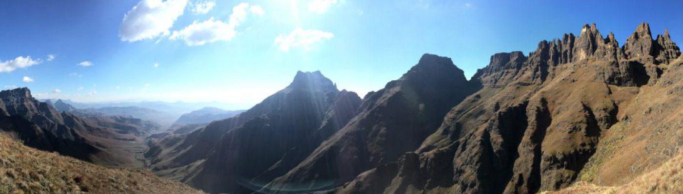
Chamonix is the staging ground for many mountain adventures. Mont Blanc (Western Europe’s highest peak at 4810m) towers above town. Mont Blanc also defines the border between Italy and France.
The adventure I describe here is the Trail du Mont Blanc. This is a multi-day hiking trail which starts in the Chamonix valley and traverses the lower slopes of Mont Blanc. There are many variations and ways of doing the trail. Slack packing to continuous nonstop running adventures for the cream of international trail runners take place here.
The TMB hosts the best trail runners from all over the world at the end of August for the Ultra Trail du Mont Blanc. Entry is limited and you have to qualify by doing smaller races before. The UTMB is probably Europe’s hardest trail race at 166km and needs to be completed in under 46h. Not an easy task if you consider adding in 9500m of ascent (and descent) too.
In fact the up (and down) hills are so brutal that they will punish all but the strongest.
Let me not scare you off though!
There are however several ways in which you can experience this tour de force at your own pace.
You can either run, fast pack or be as self sufficient as you like. You can also do sections and spend as little as a few hours to several days on the trail. Better still you don’t have to book the trail and admin is down to a bare minimum.
Travel to Chamonix:
The best way to get to Chamonix is to fly to Geneva Airport and then take a shuttle from arrivals to your accommodation in Chamonix. The best shuttle services are either Chamexpress or Mountaindropoffs. Both have regular shuttles and are reliable for this 90 minute journey. Prices are about 29 Euros or so (2013). This gives enough time to quiz the drivers who are usually very well informed on any other info you would like to know. Shuttles can be booked on line. Best not leave this for the last thing though as you can’t book online within the last 24 to 48 hours before your intended shuttle.
Accommodation in Chamonix:
There is a huge selection of accommodation in Chamonix from hotels to dorms and camping. If you are there for a week you can rent an apartment which is quite convenient.
In Cham three options stand out for those on a budget:
The Vagabond is true British bunk house. Rooms are shared and it is within walking distance from the centre of town.
Refuge Le Chamoniard Volant offers bunk rooms with 4-6 persons per room. It is situated a couple of minutes walk up the valley, just off the main road.
Camping de la Mer de Glace is awesome. It is a few minutes by bus out of town, up the valley towards Argentier. There is a small grocer close by so it is not essential to go into the main town for basic supplies.
For all of the above ask your host for a Carte d’Hôte. This allows you free access to the busses that travel up and down the valley from Les Houches to Valorcine. This is by far the easiest way to get around and super convenient if you intend to do day trips into the hills.
All the above offer a baggage hold facility while you are on the trail, also free wifi so that keeping your tweeps updated should be easy.
For those with a bit of time you can catch the free bus to les Houches down the valley and do your grocery shopping here. This will save you significantly if you can afford the time.
Preparing for the trail:
What surprised me both times I visited the trail is how steep the up and down hills are. The biggest difference to trails in SA is that you will hardly encounter any steps. Rather just a very steep incline. It is well worth training this. Find the steepest MTB single track trails and go up and down them as often as possible. Or even training on the steepest tar road will help. The terrain underfoot is not technical at all so I would not worry about that.
Navigation, Accommodation, Gear:
Route finding is straight forward and accommodation is easily found in the many Refuge’s along the way. These all offer a bed in a dorm (or room of 2 or 4). Dinner is served at about 18h30 or 19h00 and breakfast is included and generally served at 7h00. Showers are free. You might want to call one day ahead just to make sure, especially if you want a private room or are a group.
If you plan correctly you can carry little more than a day sack and rely on resupply along the way. Just be aware that shops generally close between 13h00 and 15h30 so you may catch main towns during their lunch hour. Be flexible. You can also get around using English although and introductory “Bonjour” does seem to go a long way. French is the language of the trail.
There are four major passes to cross over 2400m and six other big climbs which take you to about 2000m.
For those with several ultras under the belt and some trail running experience I recommend taking 4 – 5 days to complete the circuit. Please follow the link of my description of how I did the trail in July 2013 here.
Options and ways of doing the trail:
There are many ways of doing the whole trail or any part that you would like. It is also fairly easy to bail out from St Gervais, Courmayeur, Trient and Valorcine. I think it should be pretty easy to escape at Champex Lac too. There is a direct bus from Chamonix to Courmayeur (78km) so it is super easy to do half the trail. If this is your choice then I would recommend going from Les Houches to Courmayeur.
I can recommend breaking the trail at the following Refuges. They look nice and seem to be in a superb location:
La Balme 39km
Refuge De La Nova 50km
Refuge des Mottets 56km
Refuge Elizabetta 63km
Refuge Bertone 82km
Refuge Bonatti 90km
Refuge Elena 97km
Gite Bon Abri 125km
If you want to do only a few sections of the trail then I can recommend St Gervais to Courmayeur. Catch a bus to St Gervais and this part of the trail will give you the longest section away from towns and up into the remote hills.
Other trails to be done as day excursions out of Chamonix are:
Col de Montets to Chamonix
This is the last 15km with some of the best views of the entire trail. You look across the Chamonix valley at the Drus, Aiguille du Midi and Mont Blanc. Take the free bus to the start and enjoy! The first climb above the Col is brutal with its switchbacks but you are rewarded with a traversing trail which is very runnable. You can do several variations and you might need to keep your navigation head on not to get off the official UTMB route if you are being purist. It is pretty difficult to get properly lost though especially in good weather as the valley below is an obvious guide.
Montenvers Mer de Glace via Aiguille du Midi halfway station down to Chamonix.
Awesome views of the Brevent. Start off with a cog railway ride up to the Mer de Glace at 1913m. This glacier is really worth a visit. From the main train station ascend a little before starting the gradual traverse across the Plan de l’Aiguille to below the Aiguille du Midi halfway station. Descend the long switchbacks into town. This is essentially the opposite of the Col des Montetes to Cham route described above.
Le Tour, Col de Balme, Trient, Cantogne, Valorcine (or carry on to Chamonix)
Absolutely awesome!
Catch the free bus to Le Tour and slog up the steep ski slope. Cross over the border into the land of Toblerone and enjoy the fast and FANTASTIC to Trient. You can buy some snacks at the bus station before you head back up the immaculately maintained path to Cantogne. Traversing towards Valorcine gives you a great view of high up dam just on the Swiss side of the border. Enjoy the sweeping descent into town.
Other prep:
Training:
Work towards spending all day on your feet. You will walk a lot so train this.
I recommend going to the UTMB websiteand reading as much as you can here. Most of the info for the race will be relevant to you. If you are lucky you know somebody from whom you can download the maps of the trail.
The big challenge is altitude and the steep up and down hills. The trail is not technical at all and is incredibly well maintained and clean. I found one piece of rubbish in about 145km! People are friendly and security is not a problem at all.
Connectivity:
You get mobile phone reception for most of the way except in some remote valleys (especially the whole of the Les Chapieux valley). You can book accommodation ahead if you want but if you are one or two people and do not mind sleeping in a dorm then you should always find a spot.
Money:
Once on the trail you will need enough cash to pay for each night and for food. I used 300 euros for the four days and that was sufficient. Each night is about 40-45 euros for dinner bed and breakfast. You will get bedding but will need to hire sheets.
I did get caught out in Courmayeur when I arrived at lunch time and found the super market closed. In France expect shops to open at 10h00, close for lunch from 13h00 to 15h30 and then remain open till 19h00. Similar times in Italy and Switzerland.
Kit to take:
See my kit list below. I would recommend this as a minimum for reasonable conditions but use your discretion.
I purposefully took the smallest running pack I thought I could get away with. The Salomon 12l skin pack worked perfectly.
I ran in Ronhill shorts and an Icebreaker 150 weight short sleeve. It was great as it did not smell and dried quickly after I managed to wash it.
I wore Salomon Sense Mantra shoes. I suggest you go with a shoe that is good as an all-rounder with a little bit of support as you will be doing a fair amount of walking rather than running.
The ground underfoot is pretty mild with some significant sections of tar. So I would not worry about the best grippy sole or taking the most minimal shoes. Something that you can walk the whole day in and run some of the way is best.
I wore Injinji toe socks as they give my toes more of an individual and independent feel and action. They are my favourite but I was glad I had a spare as I got a hole in them after day 1.
Running cap and sunglasses were worn all day.
Sunscreen and lip protection are essential and needs to be applied often against the higher levels of UV at altitude.
As spare clothing I carried arm warmers for early morning starts. I did not use them once. I carried two Buff® (one for wearing during the day and the other for at night if it proved cold) I only used one Buff on the first night. I would probably only take one in future.
I carried waterproof top and longs and a pair of tights and thick base layer. I wore the base layer and tights in the evenings but otherwise good to have them for emergencies. Keep in mind I had pretty much perfect weather.
The bulkiest item was my synthetic insulation top. I wore it a little each evening so not essential but nice to have.
Toiletries: tooth brush and paste. The tiniest bit of soap and a micro towel. I did carry a good first aid kit with blister plasters which was the only thing I used out of it. Oh and I do use a safety pin to repair a zip on my pack and also to pop a blister.
My mobile phone was communication portal back home via SMS and wifi where I could get it and also I recorded photos and diary on it. Don’t forget your charger with euro plug.
I lost my headlamp but would probably only carry the lightest one possible (like the Petzl e-lite) for going to the loo at night. Everything else is overkill.
Contents of my bags was held in two ultra sil nano drybags from Sea to Summit. The lightest possible.
I carried a map and list of printed out Accommodation in a zip lock. You can download a set of maps from the UTMB website and that is sufficient.
Passport, credit card and enough cash for the trip were stashed in my pack.
I did carry a GPS to record the whole thing. I chose my Garmin fortrex 401 as it has replaceable batteries. However in retrospect I can recommend that you take any GPS unit with enough battery life to last 10h minimum. I did not use it to navigate but simply to record my journey.
Ear plugs are a necessity! You will sleep in a dorm with some level of snoring.
Nutrition and hydration:
Interestingly I drank over 5l of liquid the first day to get used to the altitude and on the last day 1,5l lasted me over 5 hours. To me that shows the quick adaptation to altitude.
I would start each day by filling the 1,5l bladder of my Salomon pack and adding one sachet of 32gi endure powder. The theory is that just having a little bit of carb regularly aids in fat usage. I certainly found that this worked but it took a couple of days to feel the benefits. Maybe more acclimatization is needed.
I carried Nuun tablets to aid hydration and recovery and they certainly helped. I catered for two tablets a day.
I also had one energy bar a day and a couple of 32gi endure tabs to keep me going before the first replenishment each day. I just could not face eating gels even when I was desperate.
What did I do well?
It is quite nice to have some food to eat straight after finishing your day. I normally finished at 17:00 so it was nice to have a pre dinner snack before dinner is served at about 19h00. (Being the cheapskate traveler I preferred to buy something in the last town, rather than pay inflated prices at the Refuge.) I also smashed back a bottle of water with electrolytes straight after finishing the day and I think this helped with recovery. I would consume at least another liter of water before bed.
I was hoping to head out early from each hut but decided that it would be better to wait for breakfast. In the end I ran much less than I thought I would so having some food inside me at the start of the day was actually quite nice. I actually ate pretty much the same as I normally would for my main meals rather than relying too much on energy supplements.
What would I do differently next time?
I was super lucky with the weather and as such probably over catered wrt warm kit for the conditions I encountered.
I would pay more attention to maintenance. Maintenance of your nutritional needs is obvious. Then maintenance of your feet. I did not pay enough attention on day two and landed up with a painfull blister on day three which ultimately caused too much discomfort on the downhills. Part of the problem was that I was not used to the type of terrain. The many, and severely steep downward inclines hammer you in a way that we are not used to in SA. I would train this more.
I would really try to take the very least and carry less water. You could probably get away with 1l max capacity if you refilled often. I did carry one 500ml water bottle up front which I would do again.
I do like having nutrition, camera and hydration easily accessible without taking off my pack. In fact the only time I took my pack off was at the end of the day or when stopped to I buy supplies.

Sounds like fun and something I would like to do (maybe I should do the race). Don't know if Dawn could do that much hiking maybe we would have to look for a shorter option.
Question: isn't there a nice hike from Mont Blanc to Zermat?
you would love it coach!
Now that I have done this I know the little tricks that can make this as easy or hard as you want.
I think Dawn can easily manage this or at least the best parts of it. You can always do the extended version with more running. The Haute Route goes from Cham to Zermat but is no easier I think.
Thanks for the info! Planning to walk/run the TMB in 5 days in 2014, so your post was very helpful. I didn't see the link to the breakdown of your 4 day circuit.